Start your day with intelligence. Get The OODA Daily Pulse.
Start your day with intelligence. Get The OODA Daily Pulse.
Bellingcat, aided by satellite imagery service Planet, and CNN, with imagery from Maxar Technologies, both provide evidence that Russia continues to steal grain shipments from Ukraine – rerouting the food shipments through Crimean ports.
Since the beginning of the war, Russia has blocked most Ukrainian ports and “maritime opportunities to export food…grain, barley, sunflower and more: ‘The world community must help Ukraine unblock seaports, otherwise the energy crisis will be followed by a food crisis and many more countries will face it,” Ukraine’s President Volodymyr Zelensky said [earlier this month].
Russian theft of grain and maritime blockades are “fueling fears of a global food crisis.”
Russia’s theft of Ukrainian grain appears to be ramping up as it continues its war on the country, according to new satellite photos of the Crimean port of Sevastopol.
Two Russia-flagged bulk carrier ships are shown docking and loading up with what is believed to be stolen Ukrainian grain in the images. Ukraine’s President Volodymyr Zelensky has accused Russia of “gradually stealing” Ukrainian food products and trying to sell them.
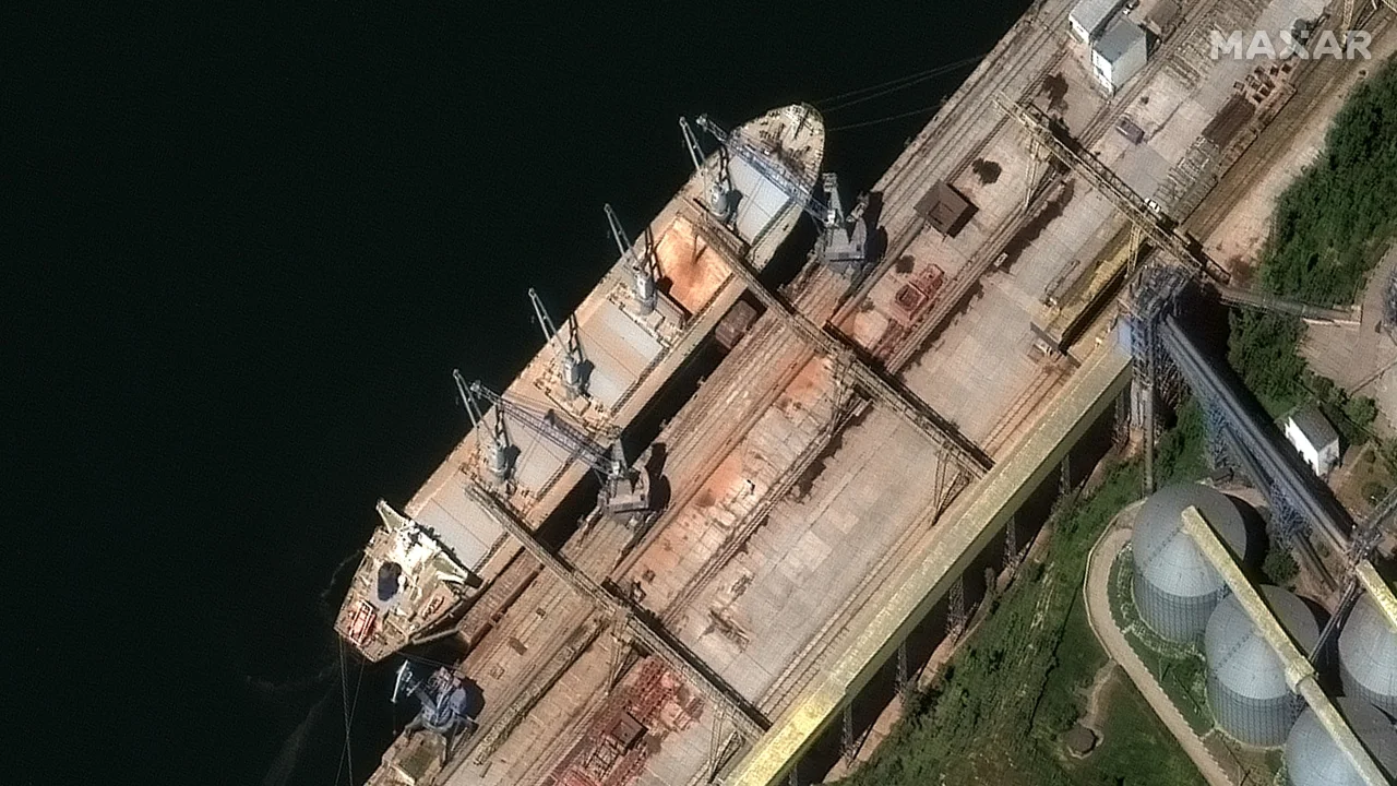
The new images from Maxar Technologies, dated May 19 and 21, show the ships – the Matros Pozynich and the Matros Koshka – docked next to what appear to be grain silos with grain pouring off of a belt into an open hold. Both ships have now left the port, according to the ship-tracking site MarineTraffic.com, with the Matros Pozynich sailing through the Aegean Sea claiming to be on its way to Beirut and the Matros Koshka still in the Black Sea.

A satellite image from Maxar Technologies shows grain being loaded into the hull of the Russia-flagged ship Matros Pozynich in Crimea
Earlier this month, the Matros Pozynich carried out a similar mission: loading up with grain and setting sail out of the Black Sea and into the Mediterranean. It was initially bound for Egypt with its cargo, but it was turned away from Alexandria after a warning from Ukrainian officials, according to the country’s government. It was also barred entry to Beirut, eventually docking in Latakia, in Syria, where Russia has for years been propping up the regime of Bashar al-Assad.” (1)

A satellite image from Maxar Technologies shows the Russia-flagged Matros Pozynich docked in Sevastopol on May 19.

On May 21 the Russian ship Matros Koshka was seen in the Sevasopol port in this satellite image from Maxar Technologies.
Source of Images (above and below): CNN/Maxar Technologies
Traditional tracking tools and ship monitoring services of the main grain terminal at the Crimean Port of Sevastopol in occupied Crimea tell a story of a port operation that has ground to a halt: ‘Automated Identification Systems (AIS) tracking data, which provides open source information on the positioning and movement of ships, shows few vessels visiting the Avlita grain terminal since Russia annexed Crimea from Ukraine in 2015. International sanctions on the city of Sevastopol and the Avlita terminal could explain why traffic has seemingly been so low.”
Bellingcat and Planet have unearthed the true activity in Sevastopol, utilizing Planet’s “satellite imaging services, social media posts, and a new Synthetic Aperture Radar (SAR) tool built as part of Bellingcat’s Tech Fellowship scheme, Bellingcat researchers and journalists “show that vessels have in fact covertly continued to make regular visits. Bellingcat identified at least 179 days in the first 12 months of Russia’s full-scale invasion where ships had been present at the Avlita terminal with their AIS transponders seemingly turned off. This appears to support the findings of several media reports that claimed activity at the terminal has continued apace.
https://twitter.com/YorukIsik/status/1629108051067150336?s=20
The Financial Times, Bloomberg, CNN, Reuters, the BBC, the Wall Street Journal and Associated Press have all reported on apparent grain exports at the terminal since the onset of Russia’s full-scale invasion, even highlighting some of the ships involved. Some have even pointed to evidence the terminal has been used as an exit point for grain taken from areas of occupied Ukraine, something Ukrainian ministers have claimed is “outright robbery” but which Russia denies.
In total, there are 148 days that ships appear to have been present at the terminal, based on Planet imagery alone.
Bellingcat has also been able to identify a further 31 days when ships were present at the terminal thanks to a Ship Detection Tool (SDT) that utilises synthetic aperture radar captured by the European Space Agency’s Sentinel-1 satellite, providing extra coverage when optical satellite imagery is not available.

This month, CNN and Bellingcat reported that:
With the permission of Planet, Bellingcat is publishing each of the satellite images from this project. They can be seen in an interactive presentation and are individually linked at the bottom of the blog post revealing the findings of this investigative project. See: https://www.bellingcat.com/news/2023/05/11/grain-trail-tracking-russias-ghost-ships-with-satellite-imagery/
Bellingcat is also sharing all SDT images [from] his story to allow open-source researchers to further investigate the vessels and the path of potential grain exports from Sevastopol.
Although an incredibly valuable and illuminating resource, it must be noted that there can still be some black spots in optical satellite imagery coverage. Visibility is limited when it’s dark and cloudy. Satellite revisit times (the time between satellite image captures of the same location) also mean full coverage is not always possible.
But peering beyond the clouds and boosting coverage is achievable with the right research techniques.
Bellingcat employed a Ship Detection Tool that uses publicly available Synthetic Aperture Radar (SAR) imagery – generated when the European Space Agency’s Sentinel-1 satellite sends out a pulse of radio waves – to gather information about the Avlita terminal.
The tool was developed as part of Bellingcat’s Tech Fellowship scheme and can be found here. A full guide on how to use the SDT, as well its other possible applications, can be found here. Bellingcat is also listing each day the SDT documented a ship at the Avlita Terminal at the bottom of this story.
While the picture generated by the SDT is very different from the optical imagery provided by other satellite imagery services, it is no less effective in confirming the presence, or absence, of a ship.
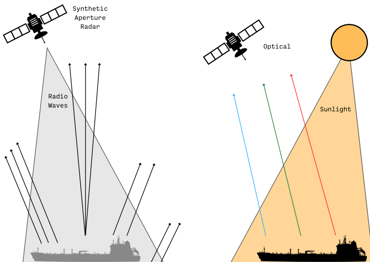
Instead of relying on reflected sunlight like optical satellites, Sentinel-1 sends a pulse of radio waves and uses the echo generated to gather information and create a picture. As well as piercing through clouds, radio waves can also display what’s going on at night.
This is similar to the way a bat uses sonar to “see” in the dark: by emitting calls and listening to echoes.

A graphic shows how SAR differs from optical satellite imagery.
What’s more, when Sentinel-1 sends a pulse of radio waves onto a flat surface like the sea there is little to reflect the waves back to the satellite. A low return signal means a darker colour is presented on any SAR image. But when the radio waves hit a ship they are reflected back to the satellite and generate a higher return signal, and therefore a much brighter colour.
This makes detecting ships fairly straightforward if they are known to position themselves at a particular set of coordinates – such as at the Avlita Terminal.
https://oodaloop.com/archive/2023/04/25/the-future-of-food-insecurity-and-agriculture-cybersecurity-grain-hoarding-rice-shortages-and-the-war-in-ukraine/